SETA
  • Home
  • Objectives
  • Case Studies
  • Consortium
  • Contact
  • News
  • Seta App
  • Media
  • Deliverables
  • Dissemination
Seta EU Project

Objectives

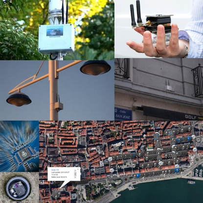
SETA creates technologies and methodologies set to change the way mobility is organised, monitored and planned in large metropolitan areas. The solutions are based on large, complex dynamic data from millions of citizens, thousands of connected cars, thousands of city sensors and hundreds of distributed databases. The project will allow us to understand and model mobility with a precision and granularity that is impossible with today’s technologies.  

The resulting models will be used to inform decision makers on how to improve town planning and infrastructure, as well as to provide support for individual citizens to plan their journeys in a more efficient and sustainable way. At the end of the project, solutions must develop to visualise and use the data, models and predictions developed in the work packages, giving access to all stakeholders, by allowing sharing and exchange of information and feedback. 

Motivations

Around 50% of the global population live in metropolitan areas, and this is likely to grow to 75% by 2050.

In some cities, transport infrastructure growth has not properly followed demand. The mismatch between demand and supply is also a consequence of the urban sprawl that has worsened the level of services of any type of transport system. 

Traffic congestion costs the EU economy an €200bn a year, and the impact of congestion is worse in urban centres where transportation CO2 and particulate pollution is generated.
​
These metropolitan areas need to grow in an efficient, sustainable, and resilient way. Therefore, it is important to develop solutions to try to move cities from a quasi-total dependency on private cars to more sustainable transport modes, such as walking, cycling and public transport.

SETA

SETA solutions are based on large, complex dynamic data from millions of citizens, thousands of connected cars, thousands of city sensors and hundreds of distributed databases. SETA will create methodologies and technologies for:
  • Effective and efficient gathering of large-scale hetero-geneous data and information sensed by physical sensors, mobile devices, collected over large scale via participatory sensing and crowdsourcing, as well as derived from institutional, public and private bases
  • Designing and developing real-time, personalised and ubiquitous transport and mobility services for citizens and businesses
  • Designing and developing a dashboard for decision makers which will allow effective daily and long-term planning of transport in the metropolitan areas, as well as support resilience and safety of mobility
Picture

Sources of data

Sources of data and information integrated by SETA will be very large scale:
  • Pervasive transport information provided by static and mobile professional sensors (including traffic sensors, floating cars, GPS tracked bikes, street cameras, meteorological stations, mobile usage data etc.). Our partner, the City of Turin has over 100 street cameras producing around 850 terabytes of compressed data a year, 3,000 loop sensors and another 50 types of sensors including minute by minute tracking of dozens of floating cars (GPS) and hundreds of buses (GPS and open/close doors); all their traffic lights are sensed and controlled by their centralised models. Birmingham has over 40 types of traffic sensors, and their 90 street cameras collect over 700 terabytes of data a year. They have floating cars and 400 bikes that are GPS tracked. The city of Santander has over 20,000 sensors installed throughout the city providing continuous sensing. All the data above is so large that currently it is not retained by the city councils, missing enormous opportunities to learn from it.
  • Data and information from social sensors (citizens) who willingly provide information/data e.g. either using their mobile phones or using low cost sensors (e.g. attached to their phones) or using social media; for example, our partner The Floow, which provides solutions for telematics insurance via mobile phones to some of the largest insurers on four continents, has available petabytes of data about driving behaviour (second by second tracking of accelerometer, GPS and several other mobile phone sensors, addition of OBD data for car monitoring, etc.). This type of data is already high-volume and high-velocity (it doubles every year) but is expected to grow exponentially worldwide over the next few years with the adoption of complete telematics services for cars; for example a Ford Fusion Energi model produces 25 gigabytes of data hourly. The Floow is at the forefront of this innovation not only through the insurance world but also through collaboration with a major international car manufacturer and it is expected that they will have access to further data from millions of cars by the start of the project.
  • Large-scale data banks from business and government (e.g. open linked data, accidents records, metre by metre description of the layout of the road infrastructure -bridges, bending, and even street furniture such as lamp posts ad park benches - traffic flows records, maps, etc.). For example The Floow has access to terabytes of worldwide geospatial contextual data relating to locations such as risk, pollution, crime, street lighting, socio-demographics, typical travel speeds (85th percentile), speed limits, population levels, land usage classifications, weather background data, and so on. They also have detailed data about the worldwide mobility network split displaying topology changes (i.e. road curves, transport lines, transport junctions and interchange nodes) in transport networks. All this data is at a granularity of 10m by 10m. Birmingham City Council is providing planned and unplanned road incident data, as well as gigabytes of data on the road network, highway network, and national rail network. Turin is providing terabytes of map data. The main characteristics of this data is its variety (multi-dimensionality and multi-modality).

Services provided

​Scientific and technological advancements will concern:
  • New methods of crowdsourcing data and information from citizens over large scale via participatory sensing (e.g. via mobile phones and low cost sensors) and passive sensing (e.g. via large scale analysis of social media) that will enable pervasive, low cost, large scale high-granularity multimodal sensing over metropolitan areas
  • New methods and algorithms fusing data from thousands of sensors across the metropolitan area with citizen data and hundreds of large databases (e.g. providing road layouts, maps, raster images, social data, etc.) in highly-dynamic, high-dimensional, high-velocity, heterogeneous data spaces
  • Predictive models able to work in these complex spaces and model entire geographical regions (e.g. areas covering hundreds of kilometres and millions of people)
  • Methods for real-time mobility decision support for citizens, business and decision makers based on this large-scale, highly-dynamic, high-velocity heterogeneous multidimensional data.

Expected outcome

Expected outcome will be a replicable strategy for deploying the SETA solution in dozens of cities, including a precise strategy for involving thousands of citizens and to integrate with diverse existing infrastructures and data. The solution will then be commercialised throughout Europe by a partnership of companies combining experienced consultants and technology developers.
Powered by Create your own unique website with customizable templates.
  • Home
  • Objectives
  • Case Studies
  • Consortium
  • Contact
  • News
  • Seta App
  • Media
  • Deliverables
  • Dissemination